

Chronicles
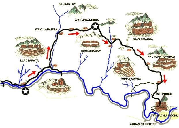
The Inca Trail and the Salkantay trek lead to Machu Picchu through Inca ruins, majestic mountains and lush forests. One steeped in history, the other more rugged, offers spectacular scenery and an unforgettable immersion in the heart of the Andes and Peruvian culture.
See details of both itineraries below.
THE INCA TRAIL – 4 DAYS
LEVEL OF DIFFICULTY:
Despite its altitude difference, the Inca Trail is not considered an advanced trek, but rather an intermediate one, and accessible to people of all ages willing to take on the challenge, although some ill-prepared or trained people may still find it quite physically challenging. The first and last days of the trek are the easiest, the second day by far the most difficult, with the crossing of the Warmiwanusca pass at 4200m, closely followed by the third in terms of difficulty. It’s extremely rare for one person to fail to complete the trek, so don’t worry, we’ll all make it to Machu Picchu together!
A large part of the Inca Trail is made up of stone steps, some of which are quite high. We therefore strongly advise you to bring walking poles to help balance your body weight and avoid knee injuries.
IMPORTANT: Your walking sticks must have a rubber tip to protect the metal points that could damage the stone!
Hiram Bingham, the archaeologist who discovered Machu Picchu, first recognized the existence of this Inca route during his explorations in 1911 and 1915. In 1941, the Viking Foundation expedition led by Paul Fejos discovered further sections. It was on this occasion that the very important Wiñay Wayna site was discovered. It wasn’t until 1968 and the expedition led by Dr. Victor Angles that the site was uncovered in its entirety. To protect this archaeological treasure trove and the rich flora that surrounds it, the Peruvian government decided in 1981 to classify this entire sector of the Urubamba valley and the Vilcabamba mountain range as a national reserve, under the name of “Machu Picchu Archaeological Park”. The exceptional beauty of the area, where nature and man’s ingenious creation blend in perfect harmony, has made this trail a veritable pilgrimage, transporting every traveller to another world, that of the splendid Inca universe. Its worldwide recognition explains the Peruvian government’s determination to limit access to this trail in order to preserve it.
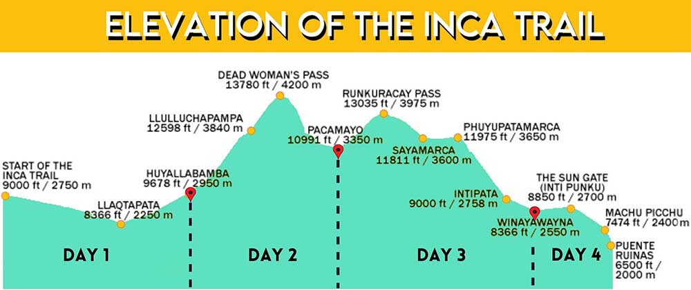
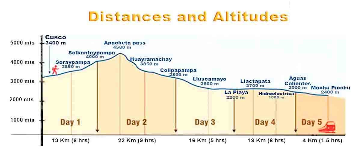
Difficulty level: Intermediate Duration: 4 days
Distance: 48 Km Difference in altitude +2310 m and -2510 m
Day 1: Piscacucho – Km 82 – Ayapata
Distance: 15 Km Walking time: 6-7 hours
Altitude: Min. 2650 m / Max. 3300 m / D+ : 650 m / D- : 100m
Temperature: Day 24º C / Night 6º C Level of difficulty: Moderate
Transfer from your hotel to the start of the trek in Piscacucho. The area is also known as km 82 of the Cusco – Quillabamba railroad.
Preparation and introduction to the team of porters and cooks for the trek.
*** The ground mattress provided by our team for the trek will be given to you at this point, at the start of the trek, and must be carried and managed by you or your extra porter during the 4-day trek (approximate weight of the ground mattress = 800 g / person).
After a few minutes’ walk, permit check at the mouth of the Cusichaca suspension bridge (built with steel cables).
This is followed by a crossing over the Urubamba River and a short walk through a small eucalyptus forest before reaching the archaeological remains of Llactapata (approx. 2h30).
Llactapata, or “village of the heights”, is an archaeological complex located at the foot of a mountain on the left bank of the Cusichaca River, a tributary of the Urubamba. The site includes numerous Andean terraces, which were probably used to feed the inhabitants of other towns and “tambos” (warehouses) on the Inca Trail. This area boasts over 100 structures and an Inca altar called “Pulpituyoq”, its climate is generally warm and the landscape colored by the area’s magnificent broom.
After lunch, the route climbs to the Wayllabamba camp, where a second and final check is necessary, before continuing on for 3 km to the Tres Piedras campsite. The campsite is close to Patawasi, where you can see Inca terraces and the remains of buildings.
Evening meal and overnight in a tent.
Porter’s note: An extra porter is included in the price of this quote. A total of 15 kg of personal equipment to be divided between participants. The ground mattress provided by our team should be included in the weight carried by the porter (approximate weight of ground mattress = 800 g / person. 1 person 800 g, 2 persons 1.6 kg, 3 persons 2.4 kg: to be subtracted from the total 15 kg) It is also possible to take more extra carriers to increase the quantity carried per traveller, up to a ratio of 1 extra carrier for every two travellers (7.5 kg carried per traveller.)
Included: lunch (without beverage), collective trekking equipment (personal sleeping bag excluded), guide (trekking), 4-day Inca Trail permit, half-board trekking, night in tent, collective equipment porterage with mules, transport, extra porter.
Day 2: AYAPATA -CHAQUICOCHA
Distance: 15 Km Hiking hours: 8-10 hrs Aprox.
Altitude: Min. 3300 m / Max. 4200 m. / D+ : 1350 m / D- : 970 m
Temperature: Day 19º C. / Night 4º C. Difficulty level: Difficult
This is the longest and most difficult day of the trek. It includes a long (approx. 9km) and fairly steep ascent to the Warmihuañusca abra at 4200 m altitude (literary translation in Quechua: “place where the woman dies”). The natural environment changes as we gain altitude, the temperate valley gradually giving way to vegetation-free pastures where ichu, a local plant adapted to these difficult conditions, is grown. Short break at Llullupampa to regain your strength before arriving at the Warmihuañusca pass After crossing the abra and regaining your strength, the descent begins to the Pacaymayo river valley, where you will find a small waterfall and lunch.
The day continues with the crossing of a second pass, from where we can observe the archaeological remains of Runkuracay, at an altitude of 3,800 metres. Runkurakay owes its name to its semi-circular shape, providing protection from the area’s powerful winds. The complex has a single entrance with 7 entrances to 7 different rooms.
Descent to the Yanacocha lagoon (black lagoon) and arrival at Sayaqmarca or “dominant village”. This Inca ruin, whose only access is a steep stone staircase up the mountainside, offers a breathtaking panoramic view of the Acobamba Valley and the snow-capped summit of Pumasillo.
The walk continues to the Conchamarka site, a small, recently discovered archaeological complex, before arriving at the Chaquicocha camp where you’ll spend the night.
Evening meal and overnight in tents.
Note: Given the high altitude of the Warmihuañusca pass (4200m), it is possible to feel the effects of soroche, or altitude sickness, on this day. Given the altitude of the pass, temperatures are generally quite low, and gusts of wind can blow strongly. It’s very important, especially on this day, to keep your own pace, as too fast a pace can make the end of the day rather hard and the following day difficult.
Included: collective trekking equipment (personal sleeping bag excluded), guide (trekking), night in tent, full trekking board, collective equipment porterage with mules, extra porter.
Day 3: CHAQUICOCHA – WIÑAYHUAYNA
Distance: 11 Km Walking time: 5-6 hrs. Aprox.
Altitude : Min. 2700 m / Max. 3720 m. / D+ : 50 m / D- : 1020 m
Temperature : Day 24º C. / Night 9º C Level of difficulty : Easy
This is the shortest day of the trek, beginning with an ascent and passage through the first “tunnel” of the trail, about 20m long and cut into the rock.
The climb continues to the third and final pass on the way to the citadel of Phuyupatamarca. Meaning “village above the clouds” in Quechua, this ruin is one of the most original on the Inca Trail. Situated in a gorge overlooking the Urubamba river, it is surrounded by forest and features numerous Andean terraces and ceremonial springs.
On sunny days, you can enjoy the scenery of the Urubamba Valley and adjacent glaciers. The lower part is made up of circular constructions following the geographic shape of the land.
Once past the ruins of Phuyupatamarca, the trail begins a descent before opening onto ledges overlooking the Rio Urubamba to the site of Wiñayhuayna. Wiñayhuayna, or “forever young”, lies at an altitude of 2644 metres. Its name is due to its typical red, yellow and violet orchids, which bloom all year round and abound in this area. Built on the steep mountainside on the left bank of the Urubamba, it was the last urban center before Machu Picchu.
The ruins are made up of 4 main sectors: the urban sector (located on the lower part) comprising over 20 buildings, the Ritual Springs sector, the Cultivation Terraces sector and the Tower sector (probably a religious or royal site).
The day will be short, with lunch and dinner at the Wiñayhuayna camp. You’ll then have the afternoon to rest and/or visit the nearby ruins.
Overnight in a tent in Wiñaywayna.
Includes: collective trekking equipment (personal sleeping bag excluded), guide (trekking), night in tent, full trekking board, collective equipment porterage with mules, extra porter.
Day 4: WIÑAYHUAYNA – MACHU PICCHU – AGUAS CALIENTES
The Incas always built their fortresses in places where they could see without being seen, attack without being attacked. The mysterious citadel of Machu Picchu, on the edge of the jungle, is hard to find. On this last stretch, you’ll see the Urubamba River. It flows from the high Andes into the deep jungle, forming a series of meanders along the high walls of centuries-old rock covered with dense woodland.
The path continues beside a massif suspended over a deep abyss with green slopes, descending to the roaring rapids of the river thousands of metres below. At every turn along the way, you’ll discover a different species of flora and fauna and a new perspective on the impressive landscape.
After around 3 hours’ walking, you’ll arrive at “Intipunku” or Sun Gate. This small complex of buildings served as a checkpoint or vigilance post. This entry point is ideal for taking perspective photos of the whole of Machu Picchu.
Built around 1450 by Emperor Pachacutec on a cliff 400m above the valley, Machu Picchu was first and foremost a religious sanctuary, where the exceptional stonework proves that it was inhabited by Inca nobility. The city is divided into 2 main sectors, one agricultural and the other urban, and despite its strategic position, the weakness of the fortifications suggests that the city had a minor military role. There are over 200 stone buildings.
The city was probably abandoned even before the arrival of the Spanish, and fell into oblivion until its rediscovery in 1911 by Hiram Bingham. Today, it is a World Heritage Site and has been officially named one of the New 7 Wonders of the World. The discovery of Machu Picchu, a mythical site, is without doubt a unique and magical experience, reconnecting you once again with your childhood imagination. Exploring the city in detail could take days, with the official academic tour taking around 3h00.
End of the tour and descent to Aguas Calientes. Overnight at Hotel Casa de Luz. (standard room).
Includes: one-way bus to Machu Picchu, trekking morning meal, collective trekking equipment (personal sleeping bag excluded), guide (trekking), entrance to Machu Picchu, collective equipment portage with mules, extra porter, room & breakfast.
Distance: 7 Km Walking time: 3 hrs. Aprox.
Altitude : Min. 2400 m / Max. 2700 m / D+ : 150 m / D- : 450 m
Temperature : Daytime 27º C. Level of difficulty: Easy
Day 5: AGUAS CALIENTES – CUSCO
From Aguas Calientes (train departure: 08:30 am), travel in comfort on board the Inca Rail “Voyager” return train to the village of Ollantaytambo (train arrival: 10:10 am).
Admire the scenery of the Sacred Valley, with its imposing mountains, snow-capped peaks, winding river and gradually changing vegetation.
Enjoy a variety of homemade natural beverages, prepared with Andean herbs representative of the region.
An unforgettable experience in the heart of the Andes!
Private transport from Ollantaytambo train station to your hotel in Cusco.
Overnight at the Hotel Anden Inca in a standard room.
Includes: train ticket, transport, room & breakfast
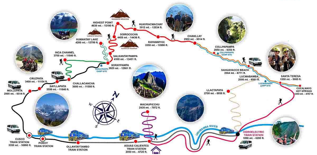
SALKANTAY TREK – 4 DAYS
This route was used and recognized in both Inca and colonial times. The mountain named Salkantay is a so-called APU mountain, i.e. a sacred mountain revered by the Incas. It runs around Mon Salkantay, a wild mountain in Quechua and the highest peak in the Vilcabamba Cordillera (6250m). It’s also well known as an alternative route to the famous Inca city of Machu Picchu.
The scenery is spectacular, as the road winds its way between mountains and valleys, passing very close to the Salkantay glacier. It is less busy than the Inca Trail, making it an excellent alternative to the Inca Trail for getting to the famous lost city of Machu Picchu. You can enjoy hiking through deserted valleys, mountain passes and cloud forests. It’s the perfect place to set off in search of adventure! On this trail, you’ll be able to explore and discover reserved nature.
Day 1: CUSCO – MOLLEPATA – SORAYPAMPA
Morning departure from your hotel by vehicle with your crew to cross the Anta valley, then descend into the depths of the Apurimac canyon. Before reaching the Apurimac River, leave the asphalt track for a climb on a dirt road to the Mollepata plateau, where you’ll find the village of Mollepata (2,800 m), where you’ll begin your trek. This village is the last point of civilization for a few days, so if you’re missing anything, it’s now or never. The trek from Cusco to Mollepata takes around 2h30 and is a beautiful one.
Your mules will be waiting for you in the village to start the 18km walk to the grassy Soraypampa platform (3,900 m). The trail begins with a steep slope up to a canal at around 3,300 m altitude, which is the biggest challenge of the day (some guides can simply take the country path to Soraypampa). Once at the canal, the climb continues to Soraypampa, but is much gentler. The trail follows the valley, gradually approaching the heart of the Vilcabamba Cordillera, and in particular the glaciers of Humantay (5,910 m) and the highest mountain in the Cordillera, Salcantay (6,260 m). The last section of the trail is on an abandoned country road. Arrival at the small Soraypampa plain. Set up camp. Overnight in tents.
ABOUT 7 HOURS OF HIKING, D+ : 1270 m / D- : 170 m / 18 km
Lunch, dinner and supper included
Day 2: SORAYPAMPA – WAYRAQMACHAY
Early morning departure from 3,900 m altitude to cross the highest pass of the trek, at 4,650 m altitude, before descending to another grassy platform: Wayraqmachay, also at 3,900 m altitude. The ascent is gradual, as you climb up the frontal moraine of the Salcantay. The climb takes all morning, and the last part is particularly tough, both for the percentage of climb and the altitude. The pass offers superb views of the Salcantay glaciers.
On the other side begins a descent similar in distance to the ascent, to the Wayraqmachay plain. Overnight on this small grassy plain, which takes its name from Wayraq, meaning wind! Overnight in tents.
ABOUT 6 HOURS OF HIKING, D+ : 800 m / D- : 750 m / 12 km
Breakfast, lunch and dinner included.
Day 3: WAYRAQMACHAY – PLAYA-HYDRO
It’s a magical day: blue skies, clear air and, above all, all the glaciers forming a horseshoe around the plain. The day will be almost entirely downhill, apart from a few ascents to position yourself in the valley. You’ll soon switch from the climate and vegetation of the high plateaus to a strange lush forest emerging from the clouds – a primary forest. The temperature and vegetation change rapidly as you descend, and some parts of the descent are steep. This section ends at the Chalan quebrada, in the village of Collapampa (2,870 m), perfect for lunch.
The rest of the day consists of a slow descent along the Totora River, with slight ascents, to reach the village of Playa (2060m) at the end of the day, in the rainforest. Playa is the first real village, with its wooden houses typical of the jungle. Overnight in tents near the village.
ROUND 8.30 HOURS, D+: 325 m/ D-: 2,220 m / 22 km
Lunch, dinner and supper included
Day 4: PLAYA-HYDRO – AGUAS CALIENTES
The day begins with a 45-minute ride along a narrow country road through coffee and cocoa plantations to the Inca trail of Llactapata. You’ll leave the valley floor to enter this panoramic trail rising into the mountains. The climb takes around 2 hours to reach the ridge overlooking the valley, giving you an eagle’s eye view of the region. On the crest, a dense forest gives way to the trail, which takes the form of a tunnel through the greenery. On the other side of the forest, as you start to descend on the other side, you come to the terrace of the Inca ruins of Llactapata (2,420 m). In front of you, in the distance, you can see the city of Machu Picchu, a unique viewpoint over the site.
The descent is no longer made of stone like the ascent, but rather a steep, winding dirt path, which can turn to mud in the rainy season. The descent ends an hour later at the Hydro bridge (1,860 m), the electrical station, where the railway line also ends. Your cook will be waiting for you with your meal in front of the picturesque little train station. From here, you can take a 45-minute train ride to Aguas Calientes, or simply follow the trail alongside the railway for 2 hours to the village.
Gourmet dinner at the hotel. Overnight in hotel in Aguas Calientes
ABOUT 8H00 WALKING, D+ : 480 m / D- : 560 m / 14 km
Lunch, dinner and supper included
Day 5: MACHU PICCHU – CUSCO
Early morning departure from your hotel for the bus with your private English-speaking guide. A 20-minute bus ride takes you to the gateway to the lost city of the Incas. Built around 1450 by Emperor Pachacutec on a cliff 400m above the valley, Machu Picchu was first and foremost a religious sanctuary, where the exceptional stonework proves that it was inhabited by the Inca nobility. The city is divided into 2 sectors, agricultural and urban, and despite its strategic position, the weakness of the fortifications suggests a minor military role. There are over 200 stone buildings.
The city was probably abandoned even before the arrival of the Spanish, another mystery enveloping it, and was quietly forgotten until its rediscovery in 1911. Today, it is a World Heritage Site and has been officially named one of the New 7 Wonders of the World. Exploring the city in detail could take days; the official academic tour takes 3h30.
It is possible to climb to the top of Hayna Picchu, the Inca astronomical observatory overlooking the site, provided you book early enough to buy the permit. The climb takes about an hour. Return to Aguas Calientes.
Late afternoon vistadome train to Porroy station, and transfer by land to your hotel in Cusco.
Breakfast included

Contact
Start your adventure now!
To make a reservation or for any other information, please do not hesitate to contact us. We’ll be delighted to help!
Chronicles
Our latest chronicles
Discover our latest news, tips, tricks, guides and previews of the adventure that awaits you!


Our newsletters
Our newsletters are not available in English yet. For the French version, click on Français in the upper right corner!

October 11 2025
The EES system in force on October 12th 2025
The new Entry/Exit System (EES) has been operational since October 12, 2025. European countries using the EES are gradually implementing…
May 17 2025
Inca trail and Salkantay
The Inca Trail and the Salkantay trek lead to Machu Picchu through Inca ruins, majestic mountains and lush forests. One…
April 28 2025
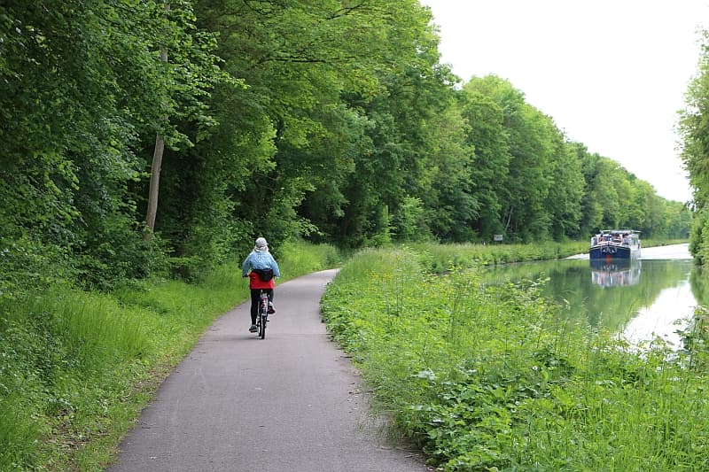
Bike&Boat formula
The bike-boat formula offers unique experiences. Why is the bike-boat package so attractive? The bike-boat package is attractive for a…